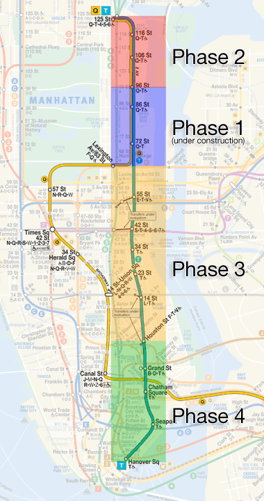
QueensWay, or No Way?
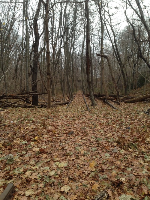
Many people in NYC (okay, just central Queens) are familiar with the long-abandoned Rockaway Beach Branch of the Long Island Rail Road (LIRR), an amazing stretch of track that runs all the way from Rego Park down to South Ozone Park. It has come into spotlight in recent years due to two competing visions: proposals for a greenway/linear park called the QueensWay-- inspired by the success of urban rail-to-trail projects such as the High Line-- and transit advocates who want some sort of rail rebuilt (varying from LIRR ‘reactivation’ to a massive project of subway conversion involving tunneling under Rego Park and connecting to the Queens Blvd subway line). In the meantime, it is (largely) a forest.

My fascination with it began growing up in South Ozone Park. As the Manhattan-bound A trains neared the Rockaway Blvd station, a large scrap-metal spider could be seen hanging on part of the abandoned line (it has since fallen, and decayed). An image of the spider in its heyday can be seen on an Angelfire site, where you can also scroll through to find images showing the line as it stood around a decade ago. Despite spending most of my life in Queens, I had never set foot on it, however. I since changed that, with several visits in the past few years.

This blog post will be a mix of sharing my own walks and images, along with some subsequent research I did to answer the questions that arose along the way.

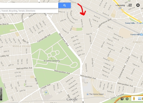
First, let’s orient ourselves via map. The following shows you where the northern end broke off from the main LIRR line, shortly before the Forest Hills stop.

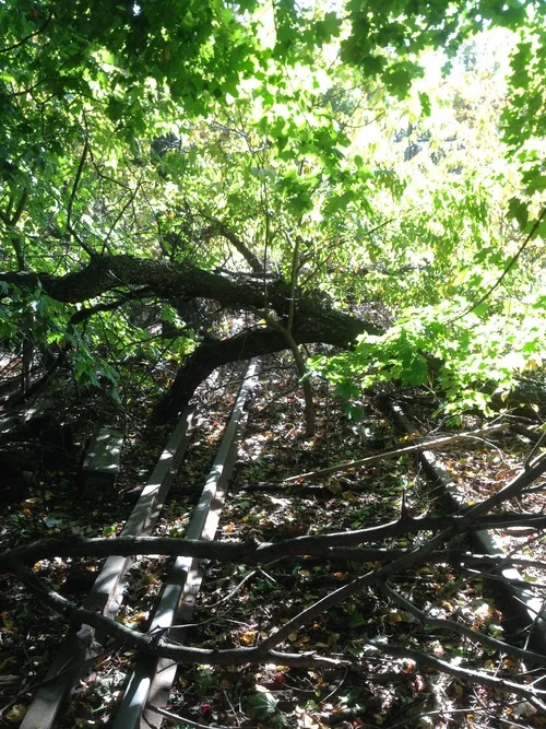
I entered the trail near there, right off of Fleet St, where it can be accessed inside a ball field, and I headed south. This end was the most overgrown, and was almost impossible to pass in some areas. Being in shape and limber is recommended (and absolutely not recommended in wet or humid weather conditions).

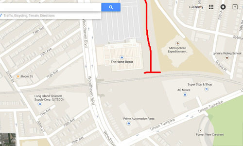
It wasn’t until I got past Metropolitan Avenue that I hit a big question mark… and a literal dead end.

It was then that I realized that this track was not as 'linear’ as it is often described.

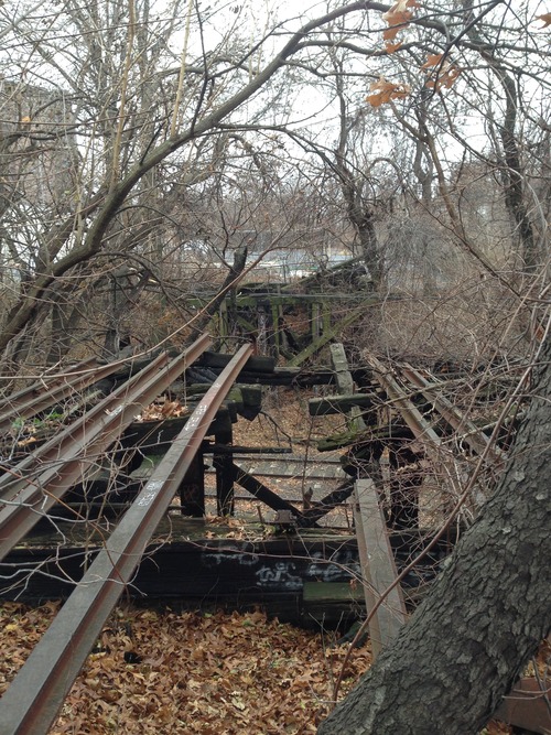
The bridge where the line once crossed the (lower, and still semi-in-use) Lower Montauk LIRR line is completely gone… collapsed, or removed, I could not determine.

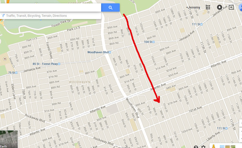
Let’s look at this point via (again) map.

I climbed down the hill onto and across the Montauk tracks where you see this:


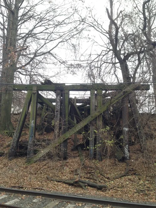
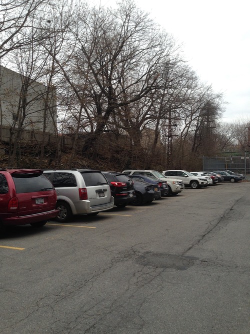
More questions arose on the other side here, where there was no more track to follow. Beyond the above trestle, there was only a parking lot. Where’d the QueensWay go? 

Just to the (west) side of this lot, however, I found another set of tracks, which curved west toward the Montauk tracks, but from there did head south. Was what we think of as one linear path actually TWO separate lines? Yes, and no.

Just ahead, where the tracks cross over Union Turnpike, it starts to get a little clearer. Here, I found two bridges, where the two lines began to come close (but not yet intersect).

The above image was taken from the bridge of the rail that came from the Montauk tracks looking east at the bridge of the rail that came south from Rego Park. (Make sense?)

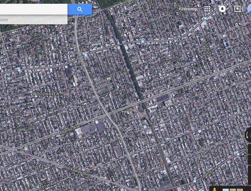
Let’s get a overall picture of how this works, via satellite map.

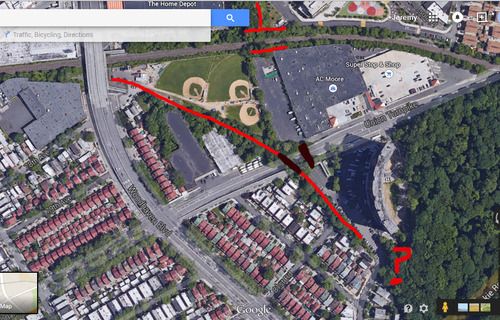
Above, you can see where the “right of way” from the Rego Park line now is gone, and has been taken over by a parking lot, and where the stretch coming from the Montauk line runs adjacent to a small ball field. The two dark red/brown lines over Union Tpke represent the two bridges. Across the western one, the line peters out into a parking lot of an apartment complex.

The “?” I added in the previous satellite map grab shows where the two lines met, and where the rail line picks back up again, at the entrance to Forest Park.

Now let’s a break from my journey to fill in some of these blanks. After I returned home, I looked up the Wikipedia page for the Rockaway Beach Branch, and found my answers. The page notes: “Steam trains continued to serve Rockaway Park from Long Island City [the Montauk line] until June 16, 1910, when the electrified Glendale Cut-off opened, extending the line north from Glendale on the Montauk Division to White Pot Junction at Rego Park on the Main Line.”

So the two lines were together from the Rockaways north to Glendale, where they separated just south of Union Tpke. In short, a lot more complicated than either side discusses in their simplified history of the line.

Back to the journey! 

The section of the park that runs through Forest Park is the smoothest, least forest-y (and most easily accessible) area, and is therefore the one I’d recommend for anyone who wanted to see this, but isn’t up to a deep forest hike.

At the end of Forest Park, over Park Lane South, fencing was put up to block the overpass bridge, but large holes have been cut through by others to make passage easy. Past there is where it starts to get wild again, and where you start to notice, as the Wiki page notes, “A number of properties adjacent to the right-of-way have expanded their property fences over sections of the former right-of-way, without acquiring the rights to the land”. Oop. Close to Atlantic Avenue is where I headed out, as a look further south seemed to indicate further passage would be quite difficult. 

Map-wise, here’s where it runs south of the park.

And with satellite image mode:


(That tree line provides a helpful illustration, no?)

After bailing from the trail, I continued on foot on street level alongside the railway to continue my journey.

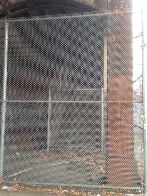
(See? Impassable. I’d never to get touch those spider remains.)

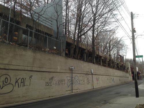
Right over here, at Atlantic Avenue, the entrance to the former Atlantic Ave station is fenced off.

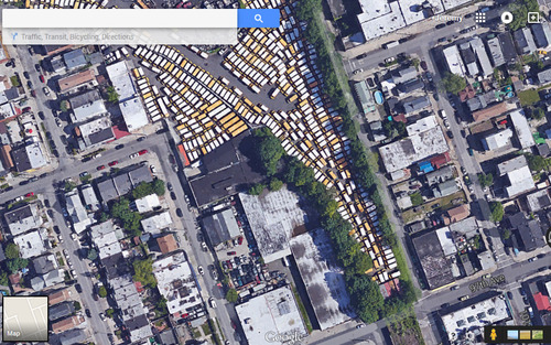
Right south of Atlantic, I noticed something curious up there… school buses?

How’d they get there? And how do they get down every day? Once again, the Wiki entry provided my answers: “The line’s connection with the Atlantic Branch at Woodhaven Junction, consisting of an interlocking, tunnel portal and incline that rose to meet the elevated Rockaway Branch, was closed and removed in October 1955. This connection had primarily been used to allow trains from Brooklyn to reach Aqueduct Racetrack. The remains of the interlocking can still be seen in the Atlantic Avenue tunnel, while the incline is now used by Logan School Bus Company, who parks their bus fleet along the incline.”

Here is a link to what remains of that incline.

And here’s what that bus lot looks like via satellite.

Soon after this point, my journey came to an end on Liberty Avenue, where the Rockaway Beach Branch meets up with the Rockaway-bound A line heading south. From Liberty, I was able to capture an image of the spider’s carcass. RIP, little guy.

I hope that this post was able to help shed some light on the Rockaway Beach Branch/QueensWay/etc, which it turns out most people don’t know that much about, myself included prior to these explorations.

Regarding the debate between park versus rail, a few of my personal opinions: I (mostly) side with the park crowd, as I feel that re-drawing Woodhaven Blvd with dedicated bus lanes and adding Select Bus Service could alleviate a lot of transit issues… and could be done in the very near future at (relatively) low cost. With the Second Avenue subway (now in its 9th? decade of planning), East Side Access for LIRR, Fulton Center, etc, the MTA has proved it is no longer capable of doing big ideas remotely on time or in budget. Queens residents can’t pin their transit hopes on a fantasy that this is not the case. Yes, this area could benefit from more rail. But look a subway map of Queens. Most of it is a subway dead zone. This area is less-so than most, actually. And finally, let’s be real… as the Wiki entry notes, most residents don’t want rail in their 'backyards’. Or a park. They want the status quo. NIMBY, literally.

Until you can fight that, the forest remains.

International Tourist Guides Day

International Tourist Guides Day is an annual initiative of the World Federation of Tourist Guide Associations (WFTGA), every year on February 21. It is a tradition on this day for guides to give complimentary tours to promote our industry.

I have chosen to participate this year with a special, half-hour walking tour in downtown Manhattan (please RSVP at the link if interested). This tour will take us through the interconnected, underground passageways that run under Fulton St in downtown Manhattan, starting at the Fulton Center subway station, running through the World Trade Center transportation hub, and ending at Brookfield Place. The aim of the tour is to show visitors the rebirth of downtown through its transit initiatives.

If you can't make it that day, feel free to contact me for other tour options!

New Tour: Lower East Side Street Art!

I have lots of great things planned this year, including several new tours. I have just added the first: a street art tour through the Lower East Side! This a Manhattan counterpart to my popular street art tour in Brooklyn.

This tour will be a fun one, not only for street art enthusiasts, but also for those who want to explore the historical and eclectic Lower East Side. Availability starts in a couple weeks, but booking is open now. I look forward to seeing your soon!

Come Home to New York!

Like many of NYC's finest tour guides, I am a member of the Guides Association of NYC (GANYC), and also work for their PR committee. GANYC is in the process of bidding to get New York to host the 2019 convention for the World Federation of Tourist Guide Associations (WFTGA). The United States has never been a host country for this convention before.

Here is the video that was created to make this pitch, as well to generally help sell our wonderful city and the importance of having a guide by your side. Yours truly has a small cameo when the tour bus makes it way over the Manhattan Bridge.

The concept is that, no matter where you are from, there is a little slice of home in NYC. Come home to New York!

The 1964 World's Fair... Presented by Walt Disney?

One of the unique tours that I offer is a World's Fair history tour in Flushing Meadows-Corona Park, in Queens. Having grown up in Queens, getting visitors to explore this diverse borough is a passion of mine.

This tour also intersects with another passion of mine... Disney and its many theme parks (my travel bucket list: visit every Disney theme park in the world. Halfway there!).

Walt Disney was heavily involved with the 1964-1965 World's Fair, and the legacy of his involvements remains at his theme parks worldwide today. As Disneyland's Tomorrowland (one of the original 4 sections of the park) showed, Disney shared the same obsession with an idealized, scientific future as most Worlds Fairs did. So he was thrilled to be involved. Disney created 4 major attractions for the Fair, and we'll look at each. In addition, like at his own park, costumed Disney characters roamed the Fair grounds.

Walt Disney's parks pioneered the technology of Audio-Animatronics, and he first showcased this at the Fair. For the Illinois pavilion, Disney created an attraction called "Great Moments With Mr. Lincoln", a theater show in which an animatronic Abraham Lincoln recited his famous speeches. This attraction was moved to Disneyland after the Fair, where it still runs today. An expanded version of this concept, the continuously-updated Hall of Presidents, was created for the Disney World resort.

(There were rumors that Disney was seeking to use Flushing Meadows as the sight for his planned East Coast Disneyland, but that was never confirmed, and the cold winters alone likely were a key deterrent, and the cheap land in sunny central Florida won out.)

Animatronics also featured heavily in the most famous Disney creation for the Fair... "Pepsi-Cola Presents Walt Disney's 'It's a Small World' - a Salute to UNICEF and the World's Children". In this attraction, which involved a boat ride, dolls and animals representing countries and cultures from around the world danced and sang to a tune written by Disney's favorite songwriting collaborators, the Sherman Brothers. This too was moved to Disneyland after the Fair, and the ride has been recreated in every Disney resort since. Odds are most of you have ridden it, and now have that song stuck in your head. Sorry about that.

For the General Electric-sponsored Progressland at the Fair, Disney created the "Carousel of Progress", a revolving theater where the audience moved around six stages showcasing the importance of electricity in the home, over several generations. For this show, the Sherman Brothers composed another new song, called 'There's a Great Big Beautiful Tomorrow'. After viewing this show, audiences went to a second level, where they saw Progress City, a small-scale model for Disney's original concept of EPCOT (his  Experimental Prototype Community of Tomorrow).  The Carousel of Progress was moved to Disneyland after the Fair, but was replaced and relocated to the Magic Kingdom in Florida in 1975.

Finally, for the large Ford pavilion, Disney developed the "Ford Magic Skyway". In this attraction, guests sat in a new model Ford vehicle, which drove along a track using Omnimover technology, first through the visible perimeter of the pavilion, then inside into a series of animatronic exhibitions on a trip through time... from the dinosaurs to caveman to the growth of man and technology, and into the future. Unlike the others discussed above, this attraction was not moved to Disneyland. But various aspects of it did live on in many Disney park attractions. The dinosaurs were moved to an interior portion of the Disneyland railroad ride, where they can still be seen today. The focus on car technology and power lives on in Epcot's Test Track. The self-moving transportation concept found new life in the PeopleMover. And the concept of a trip through time was largely recreated in Epcot's iconic Spaceship Earth.

There's so much history in this city that even most New Yorkers do not know about, not the least of which is the role that Queens played in shaping the Disney theme park empire for decades to come. The next time you ride It's A Small World, remember... it all started in Flushing Meadows park. And I'd love to show you around.

If you are interested in learning even more and Disney and his involvement in the World's Fair, a full-length special was created by the Disney corporation about this, and it can be viewed here:


[PS: Many other (non-Disney) attractions from these World's Fairs remain in various places around the country. The parachute jump attraction for the 1939 Fair was later moved to Coney Island in Brooklyn, where it still stands (no longer used) and is now a designated landmark. The skyway created for the 1964 Fair was moved to Six Flags Great Adventure in NJ, where it still operates today.]

Banksy + NYC

Back in October 2013, the infamous street artist Banksy did a one-month residency in New York, putting up new guerrilla art each day. Almost all of that art is now gone (removed, painted over, etc), but if you are looking for Banksy in NYC, one piece remains. On West 79th St, just east of Broadway, the building owner put a piece of plexiglass over one of those pieces, preserving it permanently.

I can help you find all kinds of street art throughout the city with a custom tour.

For information on Banksy-- images, articles, exhibition listings, and more-- see the detailed profile on this global artist on Artsy.net ....they are a fantastic resourse.

2017!

This has been a fantastic year for our company, and I am beyond optimistic for what 2017 has lying ahead of us. I thank all of my past customers and all those who've spread the word about the unique tours we have to offer.

As a tour guide, I see my job as someone who helps you create NYC memories. Someone who shows you the best of what this city has to offer, and provides you context, history, and trivia about the things you are seeing. Every visitor has different interests and priorities for their trip. Making each tour reflect that is a task, but a very fun one.  It's about making a 3-day trip feel like you fit in 5 days. And making every tour not just an academic exercise, but something fun and social. Not everyone will remember every factoid they learned on a tour... but the experience of it (was it unique? did they see it from a perspective aimed at them?), that's what you remember.

My attitude is that anyone can, say, walk through Central Park.  But not everyone can show you the spots many miss, show you the secrets, and turn the tour into an adventure. That's my job.

I have lots of tours I am excited to share with visitors (or locals!) in 2017... I can introduce you to Brooklyn. Take you back in time in Queens to the days of the Worlds Fair. Show you why street art is becoming increasingly popular in major cities around the world. Wander the winding, historic streets of Greenwich Village. And so much more.

I hope that you will consider me as a guide for your next NYC adventure. I cannot wait to help you create your perfect New York memories.


Second Avenue Subway: Addendum

Last week, I wrote an entry on the saga of the Second Avenue subway. Since then, there have been several updates. The MTA announced that the Governor will take a ceremonial first ride on New Year's Eve, with the new line opening to the public the following day. So it inches closer to reality.

This morning, the MTA gave the public an early preview of the (current) northern terminus of the line, the station at E. 96th St and 2nd Avenue. The station is quite beautiful. What remains to be seen, of course, is whether the state will leave this accomplishment be, or whether they will fulfill their promise to the city to continue building under Second Avenue, and complete all phases of the plan.

Click through the image below to see all my photos from today's open house.

Splendid Structures of New York City

I have no affiliation with this product, but I saw this print of New York's most iconic buildings (illustrated to scale!) and I wanted to share it. Even if you cannot purchase it, if you have trouble telling the second-tier NYC skyscrapers apart, it's worth bookmarking the page to refer back to the image.

(PS: Want to do an New York icon crawl, and try hit as many of these in one tour as possible? That can be arranged.)

The Second Avenue Subway

The saga of New York's endlessly-delayed Second Avenue subway is so infamous, the TV series "Mad Men" (which took place during the 1960s) used it as a punchline in one episode. New York viewers laughed. And groaned. Even during the timeline of that series, the line was already overdue... a line going under Second Avenue to replace the old east side elevated lines was first proposed in 1919.

Today, through much of Manhattan, there is only one subway line that runs up the east side. If you've ever ridden the "Lexington lines" (4, 5, or 6 trains), you know that calling them overcrowded is an understatement the size of the Chrysler Building.

The Second Avenue subway went through numerous false-starts.... in 1929, 1932, 1944, 1947, and finally actual construction beginning in the early 1970s. The city's economic crash during that decade put that to an end. In 1981, Gene Russianoff, the city's top transit advocate, referred to the line as "the most famous thing that's never been built in New York City".

The city and its infrastructure has changed so much since that initial construction that a section of tunnel dug under Chinatown can no longer be used (they will eventually dig a new, deeper, tunnel through that neighborhood).

The project continued its existence in infrastructure purgatory, until a decade ago, when all the elements aligned (political will + actual funding, etc) and construction resumed. It coincided with the start of numerous hugely ambitious NYC projects... Hudson Yards, Brooklyn Bridge Park, the new World Trade Center, and much more. The city is currently building at a rate not seen in over half a century.

The decision was made to do the work over 4 distinct phases. The first 2 phases would simply see a re-routing of the Q line up the Upper East Side, to Harlem. The final two phases would bring it all down to a southern terminus, in the Financial District. A new color (teal) and line designation (T) were decided on for the new (eventual) line.

This may or may not happen before you die.

This may or may not happen before you die.

Construction began on Phase 1 (the Q re-route) in 2007, with construction currently wrapping up at a furious pace this month. The MTA insists the first phase will open for service before the ball drops in Times Square on New Year's Eve. Total cost so far: $4.4 billion.

Here's a look at how the new subway maps will look like with this completed:

image.png

And yet, that is just one phase down, three to go. Funding for Phase 2 (bringing the Q up to a connection with the 4/5/6 at 125th St) has yet to be approved by the state, and construction is not expected to begin until 2020 (or later?). 

But still after nearly a century, New York is finally getting a subway under Second Avenue. Even if just a few stops for now. Are New Yorkers happy? Or pessimistic? Probably somewhere in between. Ask most people in the city about the Second Avenue subway, and you'll get the same answer: "I'll believe it when I see it."

And maybe soon, seeing will be believing.

The Longest Running Show Underground

My recent post about 'old-school' New York had me reminiscing about one of my favorite old Sesame Street segments... from back when the show more explicitly echoed its New York home. This one was about the subway,  "the longest-running show underground":

Sesame Street, by the way, still films here in New York City, and always has. Its home since 1993 has been Queens' own Kaufman Astoria Studios. The nearby Museum of the Moving Image will also soon be home to a permanent exhibition dedicated to works of Jim Henson.